
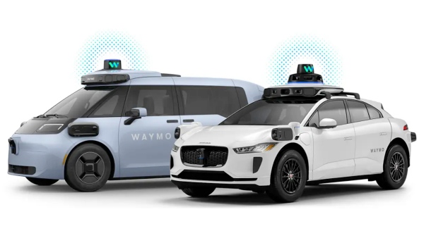
Waymo released 10 principles for developing Level 4 autonomous-driving AI based on more than 200 million miles, or about 320 million km, of fully autonomous driving experience. It said there are limits to implementing autonomous driving with cameras alone, and presented multi-sensor systems, HD maps, closed-loop simulation and independent safety validation as core elements.
On Aug. 26, EV outlet CleanTechnica reported that Waymo stressed safety as the starting point for all technology choices. It said sensor fusion using cameras, lidar and radar together is essential to safely scale up large-scale fully autonomous driving.
Waymo also distinguished the role of each sensor. Lidar identifies precise three-dimensional shapes, while cameras recognise visual information such as signs and traffic lights. Radar tracks the speed and movement of surrounding objects even in bad weather such as rain, fog and dust. Waymo explained that different sensors provide redundancy and complement one another, offsetting the limits of any single sensor.
It also cited HD maps as an important input. Waymo said maps serve as the vehicle's "memory" and provide additional information on low-visibility or complex roads. It said its AI-based mapping system continuously updates maps so the vehicle can focus its computing power on real-time variables such as detours and temporary stop signs.
Waymo shifted its AI model structure toward using a small number of large, specialised foundation models rather than many small modules. It avoided integrating all functions into a single black box. In particular, it said a pure end-to-end structure that issues steering commands directly from raw video could be risky because it is difficult to identify the cause of failures.
Instead, Waymo uses a separate, independent onboard validation layer. The system rechecks the vehicle's chosen driving path against physical laws and traffic rules, and acts as a final line of defence if it detects collision risks or rule violations.
For simulation, it stressed a closed-loop approach. Unlike simply replaying past driving data, it is designed so surrounding vehicles and pedestrians respond to the vehicle's actions, reproducing interactions similar to real roads. Waymo said this allows repeated validation of rare and complex situations and can be used for reinforcement learning.
It also operates its evaluation process independently. Waymo said its AI evaluation system called "Waymo Critic" checks not only safety and compliance with regulations on real roads and in simulation, but also the smoothness of turning and braking. It said the system is designed to prevent the development system from evaluating its own performance.
Vision-language models, or VLMs, handle high-level reasoning. They interpret meaning in situations that are hard to judge using existing training data alone, such as a police officer's hand signals. Waymo said they are not suitable for real-time control, and applied a structure that combines fast sensor-based control with slower high-level reasoning.
Waymo said it is also important to connect driving, simulation and evaluation under a single safety governance framework. It said it is building a data flywheel that continuously improves performance by linking real-world driving, user and community feedback, auto-labelling, retraining and simulation validation.
Finally, Waymo stressed that real fully autonomous driving experience itself is irreplaceable data. It said there are limits to the approach that Level 4 can be reached simply by advancing Level 2 driver-assistance technology, and that experience in which the system fully takes responsibility for driving without human supervision is important.
The disclosure of these principles is seen as meaning Waymo will maintain a safety-centred strategy that combines multiple sensors, maps, simulation and independent validation rather than a camera-centred single-sensor approach. As the technology expands into more cities and more complex driving environments, a key issue will be how it proves real-world safety and scalability.
 Jinju Hong
hongjj@d-today.co.kr
Jinju Hong
hongjj@d-today.co.kr