A domestic research team has developed a technology that combines smartphone Wi-Fi signals with a radiomap, or signal-fingerprint map, to precisely identify indoor locations.
KAIST said on Wednesday that a research team led by computer science professor Dongsoo Han (한동수) has developed a core technology to build a nationwide wireless LAN radiomap by combining smartphone Wi-Fi signals with real address information. KAIST said the technology, developed over 8 years, is seen as a "location sovereignty" technology that could change the structure of location services dominated by global big tech, including securing a golden time for searching for missing persons.
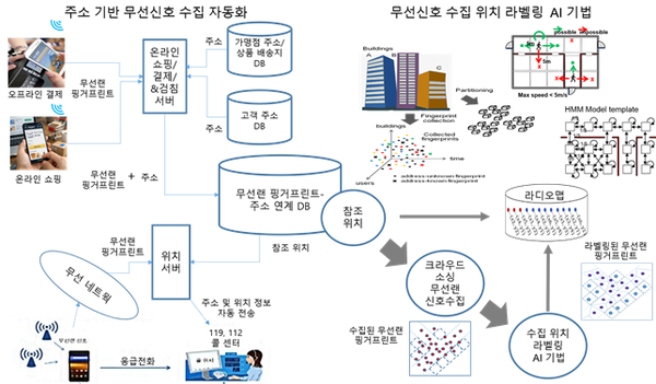
A radiomap is a database built by linking wireless LAN signals collected in a specific space with location information, and it estimates locations based on signal patterns unique to each place. It is generally built at the building level, but if expanded to the city or national level, it can enable more precise and general-purpose location services.
The key to the technology is that it uses Wi-Fi signals that smartphones collect in everyday life. It can provide precise location information anywhere nationwide without separate large-scale equipment or additional infrastructure. It can also secure high accuracy in indoor, underground and high-rise dense areas where GPS is weak.
The research team proposed a method that automatically combines wireless LAN signals collected during smartphone app use with the real address information of the location. This makes it possible to build maps of signal patterns unique to each place. If enough of these radiomaps are accumulated, precise location recognition becomes possible. The structure improves location accuracy as more data is accumulated.
The research in particular is seen as a technology that challenges the global platform company-centred structure of location services. Location data is currently accumulated and managed by a small number of big tech companies. South Korea also has high reliance on these platforms. KAIST explained that it is an alternative that can reduce dependence on global big tech as the need to secure data sovereignty grows, amid controversy over exporting "1:5,000 precision maps" overseas.
In a demonstration in Daejeon using a gas meter-reading app, the team confirmed that an average of about 30 wireless LAN signals were detected per apartment household, showing that a city-level radiomap can be built quickly. Based on this, it is expected to help secure golden time by reducing location errors that had reached hundreds of metres in emergencies such as searches for missing persons.
Han said that because building a national-level radiomap would be difficult for a single company to carry out alone, a public-private joint infrastructure is needed, with the government at the centre and cooperation among telecom companies, platform companies and research institutions. He said location infrastructure is a core asset directly linked to national data sovereignty.
The research was carried out with support from the Ministry of Science and ICT, the National Research Foundation of Korea, the National Fire Agency and the Korea Evaluation Institute of Industrial Technology (KEIT).