
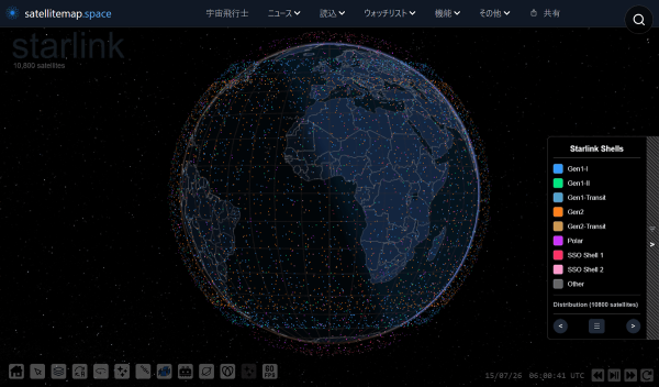
A web-based map service called Satellite Tracker has been launched to show in real time the current locations of more than 30,000 satellites orbiting Earth.
According to online media outlet Gigazine on July 15, the service displays Starlink as the default and is set up so users can check an individual satellite’s location, orbit and detailed identification information on a single screen.
On Satellite Tracker’s first screen, many dots overlap above a darkened Earth. Each dot represents a satellite. In the default setting, satellites from the Starlink satellite internet service are shown first. When a user hovers a mouse over a dot, the satellite name and identifier appear, and clicking it also displays the satellite’s orbit on the map.
It also supports real-time updates. In an example, '31667 v2 mini' was reflected on the map as it moved southeast over Japan after a short time. The selected satellite’s name is shown separately at the top right, and clicking it lets users zoom in to see which satellites are positioned around it.
The service also includes detailed information. In the information menu, users can check the satellite’s unique identifier, the 'NORAD ID', and the 'international satellite identification code'. It also provides which constellation a satellite belongs to, its hardware and generation, a diagram of its appearance, its launch time and target altitude. In the case of Starlink, it also supports a function that displays satellites by generation.
The service goes beyond a simple visualisation tool by highlighting filter-based browsing functions. In the 'Load' menu at the top, users can narrow satellites by purpose and project. Gigazine selected the low-Earth-orbit IoT satellite network 'Tianqi', operated by Beijing Guodian Gaoke Technology Co., Ltd., under the Internet of Things category and checked the related constellation.
Selection by country and research institution is also possible. In the 'Custom' menu, users can search by combining conditions such as satellite type, purpose, country and altitude. Selecting Japan alone displays only satellites launched by Japan. 'Teruteru', confirmed in this process, appeared via a NORAD ID link as a 1 kg small satellite launched on Oct. 26, 2025. Further checks showed the satellite was introduced as the palm-sized ultra-small satellite 'Teruteru', jointly developed by Komagane Technical High School in Nagano Prefecture, Kobo Okura and Hokkaido University of Science. The rocket carrying the satellite arrived at the International Space Station in October 2025, and the satellite was released into space from the station on Feb. 3, 2026.
With the recent spread of satellite internet rapidly increasing the number of low-Earth-orbit satellites, the use of such real-time tracking services is also expected to grow. Satellite Tracker not only lets users check the distribution of large constellations like Starlink, but also shows launch status by country and basic histories of individual satellites, making it possible to grasp at a glance how densely satellites are clustered in orbit.
 Jinju Hong (홍진주)
hongjj@d-today.co.kr
Jinju Hong (홍진주)
hongjj@d-today.co.kr